
Overview of Major Projects
While I participate on multiple teams as a leader, subject matter expert, and collaborator, I have included highlights of some recent and favorite projects with openly-available products to demonstrate my impact and expertise.

Dynamic Networks Experiments
Multi-laboratory virtual experiments to quantify impact of new R&D products and architectures on the event monitoring pipeline.
My Role: Experiment & Execution Lead for multi-organizational teams
of over 20 scientists and engineers.
DNE2
Over 20 scientists and engineers collaborated to execute event processing pipelines and demonstrate 2x improvement with next-generation R&D products.
Timeline Overview
10/01/2022-9/30/2024: Design, prepare, execute & deliver
Highlights, Deliverables, and Artifacts
> Papers: 15, Reports: 5+, Presentations: 20
> Established project management & systems engineering procedures, documents, and reviews to support successful, multi-organization, collaborative virtual experiments
> Engagement with stakeholders (federal agencies, national labs, and academic institutions) of innovative solutions that support resilience goals
> Computational architecture developed to orchestrate containerized algorithms across the pipeline & support virtual testbed development
> Systems reliability theory to quantify pipeline performance
> Augmentation theory & application for statistical significance
DNE3
Scientists and engineers are in development of a new experiment to drive the monitoring mission forward. Stay tuned!
Years (estimate): FY25-FY27
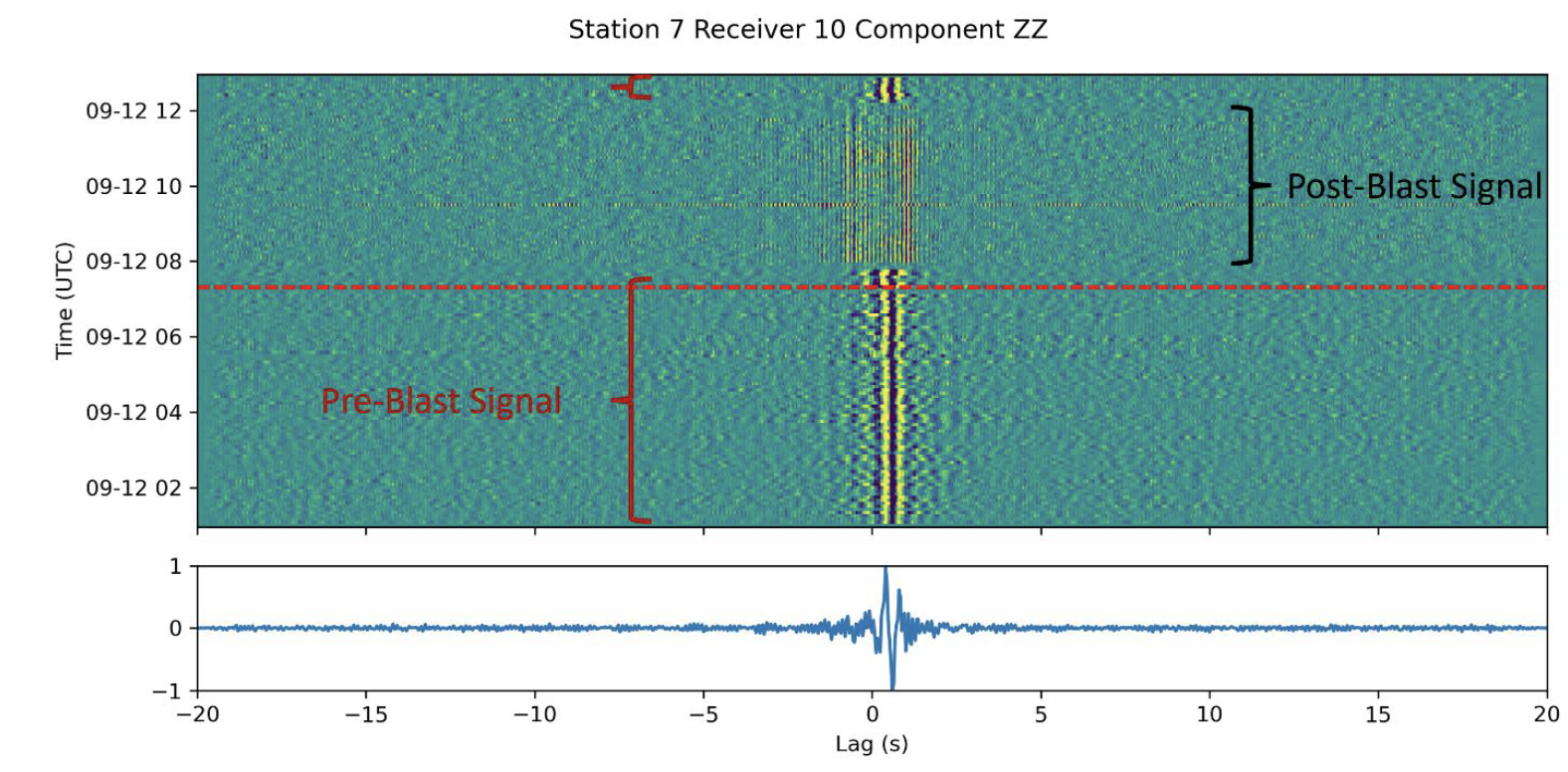
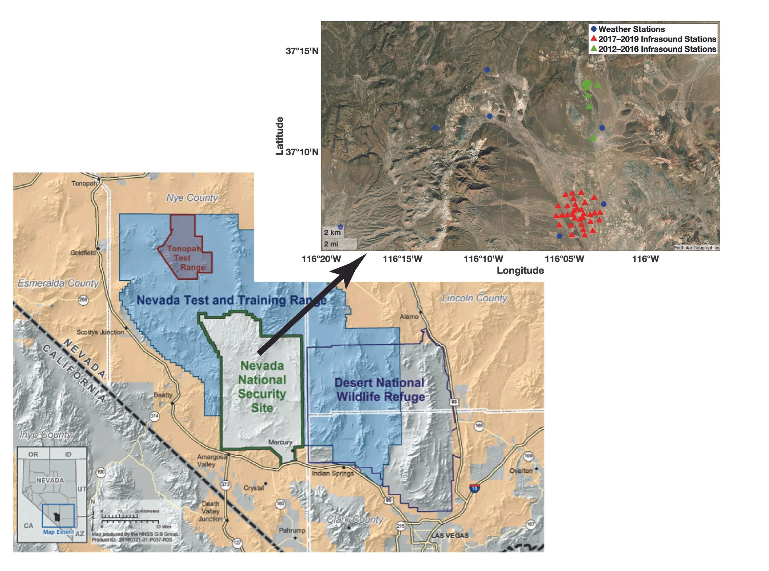
Subsurface Facility Imaging

Investigate seismic data’s ability to detect and image subsurface mining facilities and activities.
My Role: Co-Principal Investigator in collaboration between Sandia and Oak Ridge National Laboratories

My Responsibilities:
Lead the development and application of novel methods to extract and analyze ambient noise signals to advance geophysical imaging techniques.
Manage project execution, overseeing a postdoctoral researcher and coordinating with fieldwork staff to ensure timely and effective data collection, analysis, presentation and publishing.
Facilitate collaboration with cross-institutional teams and stakeholders, including quarterly reviews and documentation, independent assessments, and more. I maintain alignment of project goals with broader scientific objectives and stakeholder needs.
Organized and oversaw fieldwork involving the deployment of over 100 seismic nodes across two deployment series following NEPA standards and mining protocols while ensuring data quality and efficient operations.
Highlights, Deliverables, and Artifacts
> Developed and demonstrated new techniques to detect, locate, and characterize anthropogenic activities at facility scales.
> Multiple reports & papers (in review)
Previously released 2024 report: https://doi.org/10.2172/2430362
> Multiple presentations for broad (4 at American Geophysical Fall Meeting in 2024) & stakeholder engagements
> Two deployments to collect seismic data in collaboration with the mine site.
Data Products
Solar Systems Workings - Convective Vortices
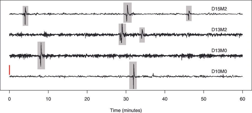
Designed a novel detection method and collaborated with NASA JPL to analyze multi-year datasets from the Nevada Mojave Desert, revealing the frequency and characteristics of dust devils.
Supervised and mentored undergraduate researchers, resulting in multiple conference presentations and coauthored publications that expanded on their contributions.
Successfully organized and presented the project’s outcomes to an independent review panel, demonstrating its impact and aligning with funding authority objectives.
Directed data management and release efforts, ensuring compliance with program protocols and enabling the public release of datasets to benefit the wider research community.
Led the development and execution to identify and characterize dust devils using infrasound sensors, advancing research on atmospheric phenomena.
My Role: Project Lead for team of 5 staff scientists and 2 interns across NASA JPL and Sandia National Labs

Highlights, Deliverables, and Artifacts
> Seven years of dust devil recordings on infrasound sensors in the Mojave Desert are openly released. With tens of thousands of records, this is likely the most complete dataset ever released – on Earth or Mars!
See the full dataset here!
> Multiple reports & papers
Paper highlight: Berg et al., 2024: https://doi.org/10.1175/JTECH-D-23-0037.1
> Multiple presentations for broad & stakeholder engagements.; highlights:
Sparks et al. American Geophysical Union Presentation 2022
Urtecho et al. Acoustical Society of America Presentation 2022
News Release: https://www.eurekalert.org/news-releases/972966
> Previously released data products also available.
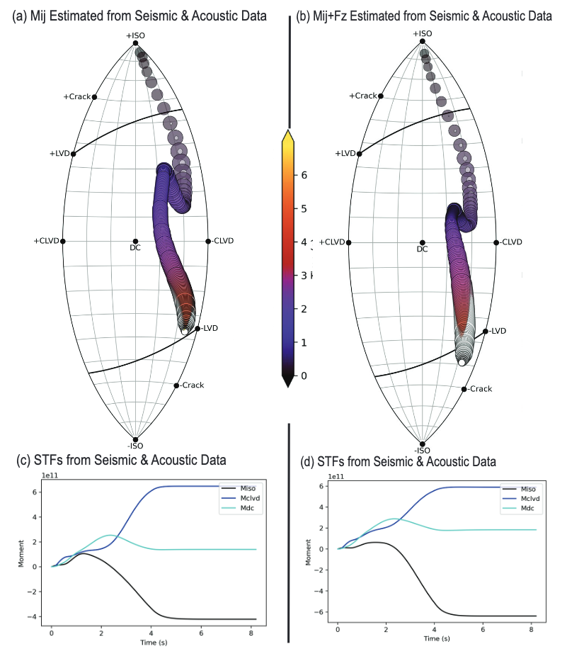
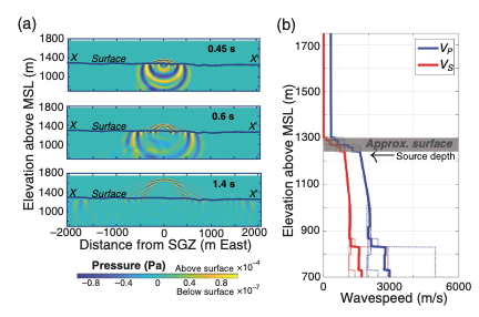
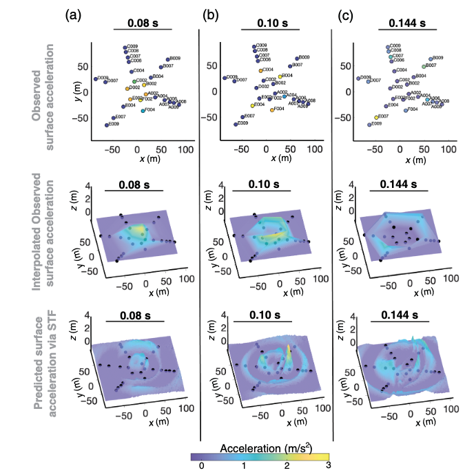
Seismoacoustic Wavefield Modeling in Complex Near-Surface Environments
Built 3D finite-difference models that capture near-surface scattering, attenuation, and mode conversions, providing insight into how complex geology shapes wavefields—directly relevant to imaging in volcanic and extensional settings.
Demonstrated that subtle structural effects (e.g., spall, shallow deformation) strongly influence recorded signals, emphasizing the need for accurate near-surface and shallow-velocity models.
Used modeling-based Green’s functions to invert for time-variable source processes, showing how evolving source behavior can mask or mimic structural features—analogous to challenges in fault/fracture imaging.
Validated that linear elastic–acoustic models can reproduce observed seismic and acoustic data, highlighting their utility in diagnosing when imaging limitations arise from geology versus acquisition or processing.
Showed that integrating multiple observables (seismic + acoustic) improves structural and source discrimination, emphasizing data fusion and incorporation of uncertainties.
I use 3D elastic–acoustic finite-difference simulations to understand how wavefields evolve in strongly scattering, attenuative, and structurally complex near-surface environments.
My Role: Developed and executed coupled elastic–acoustic finite-difference models, generated Green’s functions, and performed time-variable source inversions to evaluate how subsurface structure, spall, and deformation influence observable seismic and acoustic signals.
Highlights, Deliverables, and Artifacts
> Multiple reports & papers
Paper: https://doi.org/10.1785/0120220020
Report: https://www.osti.gov/biblio/2480201
> Multiple presentations for broad & stakeholder engagements (see CV).
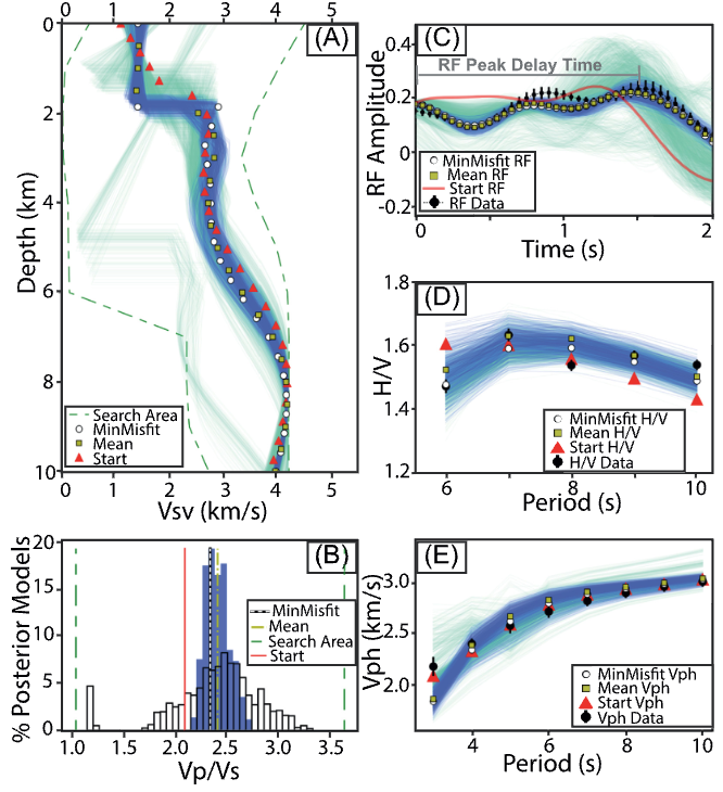
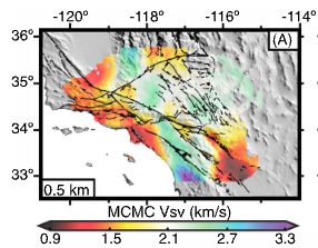
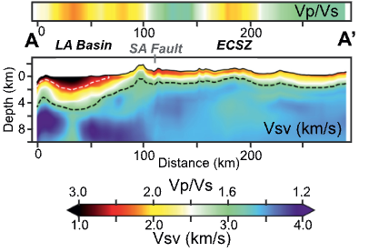
Imaging of Southern California
Resolved near-surface Vs and Vp/Vs with unprecedented regional coverage, combining Rayleigh-wave phase velocity, ellipticity (H/V), and teleseismic receiver functions into a Markov Chain Monte Carlo joint inversion framework.
Imaged basin geometry and sediment thickness, including deeper low-velocity zones in the Los Angeles, Ventura, Central Valley, and Salton Trough basins, and mapped depth to Vs=3 km/s as a basin-depth proxy.
Captured strong across-fault seismic contrasts along the San Andreas, San Jacinto, and Elsinore fault systems—key indicators of lithologic and structural segmentation relevant to fault permeability and fluid flow.
Identified low Vp/Vs outside major basins, suggesting widespread shallow fracturing and/or groundwater undersaturation—important for interpreting extensional deformation and shallow hydrogeology.
Demonstrated that “nuisance” receiver-function reverberations in basins contain valuable shallow-structure information, enabling basin imaging where conventional methods often fail.
Improved resolution of shallow structure critical for ground-motion amplification, placing constraints on sediment properties, impedance contrasts, and velocity gradients that influence seismic hazard.
Developed high-resolution seismic models of Southern California’s basins and fault systems by combining ambient-noise surface waves, receiver functions, and Bayesian inversion to reveal shallow structure and deformation patterns essential for understanding fault behavior and subsurface fluid pathways.
My Role: Led the development and application of multi-dataset Bayesian joint inversions to constrain shallow shear velocity (Vs) and Vp/Vs structure across Southern California, resolving near-surface geology, fault-zone contrasts, and basin architecture.

Highlights, Deliverables, and Artifacts
> Multiple reports & papers
https://doi.org/10.1029/2021GL092626
http://dx.doi.org/10.1029/2018JB016269
> Multiple presentations for broad & stakeholder engagements.
> Previously released data products also available:
https://ds.iris.edu/ds/products/emc-socal_bergetal2021_uppercrustvsandvpvs/
https://ds.iris.edu/ds/products/emc-socalant_vphhv-1berg2018